

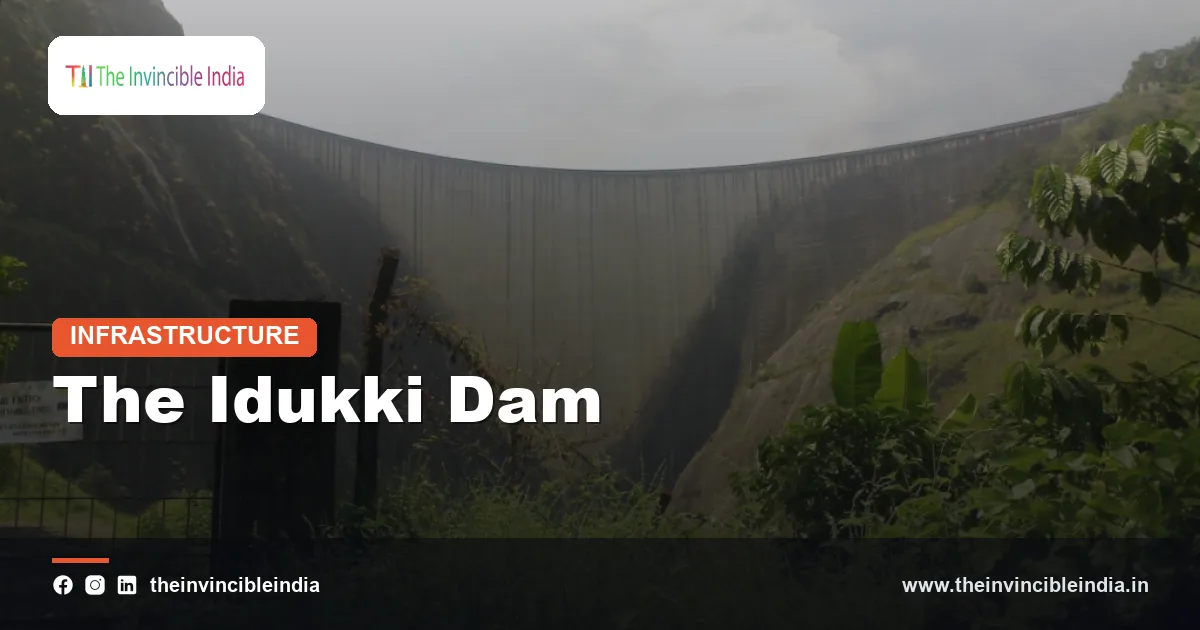
The Idukki Dam is a double-curvature concrete arch dam built across the Periyar River in the Western Ghats of Kerala, between the Kuravan and Kurathi hills, and it is one of the tallest arch dams in Asia at roughly 169 metres. The Idukki Dam forms the centrepiece of the Idukki hydroelectric project, which includes an underground power station at Moolamattom and is the largest source of hydropower in Kerala.
The Idukki Dam is notable for its engineering, because it closes a narrow granite gorge with a slender arch rather than a heavy mass of concrete. The surrounding hills form the Idukki Wildlife Sanctuary, and the reservoir has become a popular destination for travellers in the high ranges of Kerala. This explainer covers what the dam is, how it works, the wider Idukki project, the 2018 floods and the environmental setting.
| Attribute | Details |
|---|---|
| Name | Idukki Dam (Idukki Arch Dam) |
| River | Periyar |
| Location | Idukki district, Kerala, in the Western Ghats |
| Type | Double-curvature concrete arch dam |
| Height | About 169 metres (about 554 feet) |
| Construction period | Roughly 1969 to 1973; power generation began in the mid-1970s |
| Owner and operator | Kerala State Electricity Board (KSEB) |
| Power station | Moolamattom underground power house, about 780 MW installed capacity |
| Associated structures | Cheruthoni Dam and Kulamavu Dam, forming the Idukki reservoir |
Key Takeaways
- The Idukki Dam is a double-curvature concrete arch dam on the Periyar River in Idukki district, Kerala, standing roughly 169 metres tall.
- The Idukki Dam is built in a narrow gorge between the Kuravan hill and the Kurathi hill in the Western Ghats.
- The Idukki Dam is part of the Idukki hydroelectric project, whose underground power station at Moolamattom has an installed capacity of about 780 MW.
- The Idukki reservoir is held back by three dams, the Idukki arch dam, the Cheruthoni gravity dam and the Kulamavu dam.
- The Idukki Dam is owned and operated by the Kerala State Electricity Board (KSEB) and was built in the 1970s with international financial and technical assistance, notably from Canada.
- The Idukki Dam gained national attention in August 2018, when its Cheruthoni shutters were opened during the severe Kerala floods for the first time in many years.
What Is the Idukki Dam?
The Idukki Dam is a thin, high concrete arch dam that blocks the Periyar River at a narrow gorge in Idukki district, Kerala, and it stores water for the Idukki hydroelectric project. It curves in two directions, across the gorge and from top to bottom, which lets the structure pass the weight of the water into the rock walls on both sides.
The dam is one of the best-known arch dams in India and ranks among the highest in Asia. Its crest is only a few hundred metres long, which shows how narrow the gorge is compared with its depth. The slender profile saves a large amount of concrete compared with a gravity dam of the same height, which is why arch dams are favoured where the rock is strong and the valley is narrow.
The Idukki Dam is owned by the Kerala State Electricity Board and operates together with the Cheruthoni and Kulamavu dams. People often use the name Idukki Dam for the whole system, but the arch dam proper is the tall structure in the gorge.
Where Is the Idukki Dam Located?
The Idukki Dam is located in Idukki district in the central high ranges of Kerala, roughly 100 km east of Kochi by road, in the Western Ghats. It lies in a deep gorge between two granite hills, the Kuravan hill, also called Kuravanmala, on one side and the Kurathi hill, also called Kurathimala, on the other.
Idukki district is mountainous, forested and sparsely populated by the standards of Kerala. It contains famous hill stations and plantation areas, including Munnar, Thekkady and Vagamon in the wider region, and it is a major producer of tea, cardamom and pepper. The district has no large plains, and its terrain is a main reason for the strong hydropower potential of the area.
The Periyar is the longest river in Kerala. It rises in the Sivagiri hills of the Western Ghats, flows through Idukki district, and then turns west to cross the plains of Ernakulam district before reaching the Arabian Sea near Kochi. The Idukki Dam holds back a stretch of the river in its upper course.
Who Built the Idukki Dam and When?
The Idukki Dam was built by the Kerala State Electricity Board, with construction running from roughly 1969 to 1973 and power generation beginning in the mid-1970s. The project was financed in part with Canadian assistance, and Canadian engineering firms are widely reported to have taken part in the planning and design.
The project belongs to the post-Independence period of hydropower development in Kerala, a state that relied heavily on hydro generation. Early surveys of the gorge go back to the 1920s, but the large-scale project was taken up only after studies in the 1960s found that the site was highly suitable for a high arch dam and an underground powerhouse.
A well-known local account says that a tribal man named Kolumban guided a British surveyor to the gorge in the 1920s, and that the dam site was first identified through this meeting. The story is part of local tradition and is commonly repeated, although historians treat the details cautiously. Construction itself was a large undertaking in remote hill country, requiring roads, camps and the movement of heavy machinery up the ghats.
What Makes the Idukki Dam an Arch Dam?
The Idukki Dam is an arch dam because it carries the horizontal thrust of the water into the rock abutments on both sides of the gorge by means of its curved shape, instead of resisting the water mainly through its own weight. An arch dam works like a curved bridge laid on its side, with the pressure pushing the concrete into the canyon walls.
This design depends on three conditions, all of which are met at Idukki.
- A narrow valley: the gorge is deep and tight, so the arch span is short compared with its height.
- Strong rock: the granite walls on both sides can take the high loads without failing.
- Careful geometry: the double curvature spreads stresses evenly and keeps the concrete mostly in compression, which is what concrete handles best.
Arch dams use less concrete than gravity dams, but they need excellent foundations and precise engineering. Engineers monitor them through instruments that measure movement, seepage and stress. The Idukki Dam has been in service for roughly half a century and is regularly inspected as part of dam safety practice in India.
How Do the Idukki, Cheruthoni and Kulamavu Dams Work Together?
The Idukki reservoir is formed by three dams, which are the Idukki arch dam, the Cheruthoni dam and the Kulamavu dam, and together they close the gaps in the surrounding terrain. The arch dam closes the main gorge, while the other two are needed because the reservoir could otherwise spill through low saddles in the hills.
| Dam | Type | Role |
|---|---|---|
| Idukki Dam | Concrete arch | Closes the main gorge between Kuravan and Kurathi hills |
| Cheruthoni Dam | Concrete gravity | Closes a gap on the Cheruthoni river side and carries the spillway shutters |
| Kulamavu Dam | Masonry or gravity | Closes a low saddle on the opposite side of the reservoir |
The spillway gates of the Idukki system are located at Cheruthoni, not at the arch dam, which is why news reports about flood releases mention Cheruthoni. This arrangement keeps the thin arch dam free from direct spillway forces and allows the releases to be controlled from a stronger gravity structure.
How Does the Idukki Hydroelectric Project Generate Power?
The Idukki hydroelectric project generates power by sending water from the Idukki reservoir through a long tunnel and steel penstocks to an underground power station at Moolamattom, where it turns turbines connected to generators. The station has an installed capacity of about 780 MW from six units of 130 MW each, and it is the largest hydroelectric station in Kerala.
The process can be summarised in steps.
- Water is stored in the Idukki reservoir during the monsoon, when rainfall is heavy in the Western Ghats.
- Water is drawn through an intake and a power tunnel into the hill.
- Penstocks carry the water down a very large height to the underground turbines at Moolamattom.
- The turbines drive generators, and the electricity is fed to the Kerala grid.
- The water leaving the station is released into the Muvattupuzha river basin, which lies on the other side of the divide from the Periyar.
Because the water is used in a different basin, the Idukki project is an example of an inter-basin transfer, a feature that has shaped discussions of downstream flows in the Periyar. The project has also been important for the grid, since hydropower can be switched on quickly at times of peak demand. Kerala has a limited share of coal and gas generation, so the Idukki project has historically supplied a large part of the state’s electricity.
What Happened at the Idukki Dam During the 2018 Floods?
During the severe Kerala floods of August 2018, the Cheruthoni shutters of the Idukki system were opened to release water after heavy rainfall filled the reservoir, and this was widely reported as the first such opening in more than two decades. The release was carefully managed, but it added to the high flows in the Periyar and raised concerns downstream.
The 2018 floods were among the worst in Kerala’s recorded history, affecting many districts and displacing a very large number of people. Heavy and prolonged monsoon rain, saturated catchments and full reservoirs across the state all contributed. The role of dam operations in the flooding was discussed in the media and by experts, with differing views. Some analysts argued that earlier releases might have reduced peak flows, while others pointed to the unusual intensity of rainfall that no reservoir could fully absorb.
The episode led to more attention on reservoir management, early warning systems and rule curves in Kerala. Dam operators have since put greater emphasis on communication with district authorities and downstream communities when water is released. In later years the Idukki shutters have been opened on some occasions during heavy rain, usually with advance warnings.
What Is the Idukki Wildlife Sanctuary?
The Idukki Wildlife Sanctuary is a protected area of forested hills around the Idukki reservoir, established in 1976 and covering roughly 70 sq km, and it forms part of the Western Ghats landscape known for rich biodiversity. The sanctuary surrounds the reservoir and contains moist deciduous, semi-evergreen and evergreen forests.
Wildlife seen in the area is reported to include the following.
- Mammals: Asian elephants, gaur, sambar deer, wild boar, and several primates, with leopards and tigers recorded in the wider region.
- Birds: many forest species and waterbirds around the reservoir.
- Reptiles and amphibians: a variety of snakes, lizards and frogs typical of the Western Ghats.
The Western Ghats are recognised as a global biodiversity hotspot and a UNESCO World Heritage region, though specific protected areas inside it have different legal status. The sanctuary is administered by the Kerala Forest Department. Visits are regulated, and conservation of the catchment forests also helps the reservoir by limiting soil erosion and silt.
What Are the Environmental and Safety Considerations?
The Idukki Dam raises the usual environmental and safety considerations of a high dam in an ecologically sensitive mountain region, including catchment protection, landslide risk, seismic activity and dam-safety monitoring. Idukki district is prone to heavy monsoon rain and landslides, as the 2018 and later events showed.
The main points discussed by engineers and environmental researchers are the following.
- Seismicity: small tremors have been recorded in the Idukki region from time to time, and monitoring of reservoir-related seismicity is part of dam safety. Scientists differ on how strongly any tremor can be linked to reservoir loading.
- Landslides: steep slopes in the high ranges are vulnerable during extreme rainfall.
- Sedimentation: forest cover in the catchment reduces the silt reaching the reservoir.
- River flow: diversion to another basin changes flows in the lower Periyar.
- Other dams in the basin: dam safety debates in the wider Periyar basin, including the Mullaperiyar dam, are separate matters but are often discussed together by the public.
Authorities manage these issues through monitoring, inspections, early warning and disaster plans. As with other large dams, opinion differs on how to balance power generation, flood safety and ecology, and these are matters of continuing public policy.
Can Tourists Visit the Idukki Dam?
Tourists can visit the Idukki Dam area, and access to the arch dam itself is typically permitted on a limited basis, often during festive seasons, subject to security and safety rules. Visitors usually view the dam, the reservoir and the surrounding hills from designated points, and boat rides and other activities are offered on parts of the reservoir.
The Idukki Dam fits into a wider tourism circuit in Kerala’s high ranges. Nearby attractions include Munnar with its tea estates, the Periyar Tiger Reserve at Thekkady, Vagamon and Ramakkalmedu. The best time to visit is usually the post-monsoon and cooler months, though visiting conditions and opening rules change, so travellers should check with the Kerala tourism department or KSEB before planning a trip.
This article was last reviewed on 17 October 2026, and the basic facts about the dam’s design and role are expected to stay stable even as visiting rules and operations are updated.
Bottom Line
The Idukki Dam is a roughly 169-metre double-curvature arch dam on the Periyar River in Kerala, built in the 1970s to power the 780 MW Moolamattom station, and it is among the tallest arch dams in Asia. It supplies a large share of Kerala’s hydropower, sits within a sensitive Western Ghats landscape, and has become a focus of flood-management and safety discussions since 2018.
Frequently Asked Questions
How tall is the Idukki Dam?
The Idukki Dam is roughly 169 metres tall, or about 554 feet, which makes it one of the tallest arch dams in Asia. Exact figures vary slightly between sources. The arch spans a narrow gorge, so the crest is much shorter than the dam is high.
Which river is the Idukki Dam built on?
The Idukki Dam is built on the Periyar River, the longest river in Kerala. The dam sits in the Western Ghats in Idukki district, in a gorge between the Kuravan and Kurathi hills. Water from the project is released into a neighbouring basin after passing through the power station.
How much electricity does the Idukki Dam generate?
The Idukki hydroelectric project has an installed capacity of about 780 MW from six units of 130 MW at the Moolamattom underground power station. The actual output varies from year to year with rainfall and reservoir levels. It is the largest hydroelectric station in Kerala.
Who built the Idukki Dam?
The Idukki Dam was built by the Kerala State Electricity Board (KSEB), mainly between 1969 and 1973, with generation starting in the mid-1970s. Canadian financial and technical assistance is widely reported to have supported the project. KSEB continues to own and operate the dam.
Is the Idukki Dam an arch dam or a gravity dam?
The main Idukki Dam is a double-curvature concrete arch dam, while the two companion dams at Cheruthoni and Kulamavu are gravity-type structures. The arch shape passes water pressure into the rock walls of the gorge. The three dams together form the Idukki reservoir.
Why were the Idukki Dam shutters opened in 2018?
The Cheruthoni shutters of the Idukki system were opened in August 2018 because heavy monsoon rain filled the reservoir during the severe Kerala floods. Opening the gates released surplus water in a controlled way to protect the dam. Experts have debated the timing and effect of releases, and the event led to greater attention on reservoir management and warnings.
{“@context”:”https://schema.org”,”@graph”:[{“@type”:”FAQPage”,”mainEntity”:[{“@type”:”Question”,”name”:”How tall is the Idukki Dam?”,”acceptedAnswer”:{“@type”:”Answer”,”text”:”The Idukki Dam is roughly 169 metres tall, or about 554 feet, which makes it one of the tallest arch dams in Asia. Exact figures vary slightly between sources. The arch spans a narrow gorge, so the crest is much shorter than the dam is high.”}},{“@type”:”Question”,”name”:”Which river is the Idukki Dam built on?”,”acceptedAnswer”:{“@type”:”Answer”,”text”:”The Idukki Dam is built on the Periyar River, the longest river in Kerala. The dam sits in the Western Ghats in Idukki district, in a gorge between the Kuravan and Kurathi hills. Water from the project is released into a neighbouring basin after passing through the power station.”}},{“@type”:”Question”,”name”:”How much electricity does the Idukki Dam generate?”,”acceptedAnswer”:{“@type”:”Answer”,”text”:”The Idukki hydroelectric project has an installed capacity of about 780 MW from six units of 130 MW at the Moolamattom underground power station. The actual output varies from year to year with rainfall and reservoir levels. It is the largest hydroelectric station in Kerala.”}},{“@type”:”Question”,”name”:”Who built the Idukki Dam?”,”acceptedAnswer”:{“@type”:”Answer”,”text”:”The Idukki Dam was built by the Kerala State Electricity Board (KSEB), mainly between 1969 and 1973, with generation starting in the mid-1970s. Canadian financial and technical assistance is widely reported to have supported the project. KSEB continues to own and operate the dam.”}},{“@type”:”Question”,”name”:”Is the Idukki Dam an arch dam or a gravity dam?”,”acceptedAnswer”:{“@type”:”Answer”,”text”:”The main Idukki Dam is a double-curvature concrete arch dam, while the two companion dams at Cheruthoni and Kulamavu are gravity-type structures. The arch shape passes water pressure into the rock walls of the gorge. The three dams together form the Idukki reservoir.”}},{“@type”:”Question”,”name”:”Why were the Idukki Dam shutters opened in 2018?”,”acceptedAnswer”:{“@type”:”Answer”,”text”:”The Cheruthoni shutters of the Idukki system were opened in August 2018 because heavy monsoon rain filled the reservoir during the severe Kerala floods. Opening the gates released surplus water in a controlled way to protect the dam. Experts have debated the timing and effect of releases, and the event led to greater attention on reservoir management and warnings.”}}]}]}


